


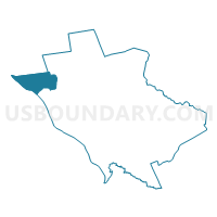
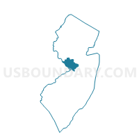
Hopewell township voting district 3, Mercer County, New Jersey
About
Outline

Summary
| Unique Area Identifier | 619595 |
| Name | Hopewell township voting district 3 |
| County | Mercer County |
| State | New Jersey |
| Area (square miles) | 9.00 |
| Land Area (square miles) | 8.71 |
| Water Area (square miles) | 0.29 |
| % of Land Area | 96.78 |
| % of Water Area | 3.22 |
| Latitude of the Internal Point | 40.32625170 |
| Longtitude of the Internal Point | -74.88759690 |
Maps

Graphs
Select a template below for downloading or customizing gragh for Hopewell township voting district 3, Mercer County, New Jersey


Neighbors
Neighoring Voting District (by Name) Neighboring Voting District on the Map
- Hopewell township voting district 2, Mercer County, NJ
- Hopewell township voting district 4, Mercer County, NJ
- Hopewell township voting district 7, Mercer County, NJ
- Hopewell township voting district 9, Mercer County, NJ
- SOLEBURY TWP VTD LOWER 02, Bucks County, PA
- UPPER MAKEFIELD TWP VTD 01, Bucks County, PA
- UPPER MAKEFIELD TWP VTD 03, Bucks County, PA
- West Amwell township voting district 2, Hunterdon County, NJ
Top 10 Neighboring County Subdivision (by Population) Neighboring County Subdivision on the Map
- Hopewell township, Mercer County, NJ (17,304)
- Solebury township, Bucks County, PA (8,692)
- Upper Makefield township, Bucks County, PA (8,190)
- West Amwell township, Hunterdon County, NJ (3,840)
Top 10 Neighboring Elementary School District (by Population) Neighboring Elementary School District on the Map
Top 10 Neighboring Secondary School District (by Population) Neighboring Secondary School District on the Map
Top 10 Neighboring Unified School District (by Population) Neighboring Unified School District on the Map
- Council Rock School District, PA (72,458)
- Hopewell Valley Regional School District, NJ (21,811)
- New Hope-Solebury School District, PA (11,220)
Top 10 Neighboring State Legislative District Lower Chamber (by Population) Neighboring State Legislative District Lower Chamber on the Map
- General Assembly District 23, NJ (229,972)
- General Assembly District 15, NJ (204,558)
- State House District 29, PA (66,505)
- State House District 178, PA (61,167)
Top 10 Neighboring State Legislative District Upper Chamber (by Population) Neighboring State Legislative District Upper Chamber on the Map
- State Senate District 10, PA (259,178)
- State Senate District 23, NJ (229,972)
- State Senate District 15, NJ (204,558)
Top 10 Neighboring 111th Congressional District (by Population) Neighboring 111th Congressional District on the Map
Top 10 Neighboring Census Tract (by Population) Neighboring Census Tract on the Map
- Census Tract 1054, Bucks County, PA (8,190)
- Census Tract 38, Mercer County, NJ (6,746)
- Census Tract 118, Hunterdon County, NJ (3,840)
- Census Tract 1043.04, Bucks County, PA (1,251)